Description
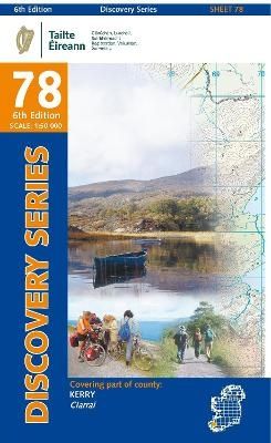
mit dem höchsten Berg von Irland
Features shown on the Discovery series include walking trails, cycle routes, forest parks and nature reserves. There are also tourist information such as campsites/caravan parks, youth hostels, tourist information offices, picnic places, standing stones, battlefields, golf courses and viewpoints. Available as a paper, folded map. Please see back cover image for the area covered.
| Gewicht: | 85 g |
|---|---|
| Verlag: | Ordnance Survey UK |
| Reihe: | OSi Discovery Maps |
| Maßstab: | 1:50.000 |
| Medienart: | Karten |
| Sprache: | Deutsch, Englisch, Französisch, Irisch-Gälisch |
| EAN: | 9781912140398 |
| Höhe in mm: | 200 |
| Breite in mm: | 120 |
| Erscheinungsjahr: | 2024 |
| Kontinent: | Europa |
| Land: | Irland |
| Region: | Münster, Kerry, Dingle Bay, Macgill Cuddy’s Reeks |
| Orte / Berge / Seen: | Killarney, Kenmare, Carrauntoohil, Lough Leane, Killorglin, Lough Caragh |


Reviews
There are no reviews yet.